
Fowler Avenue Connection

About the Fowler Avenue Connection Project
The Fowler Avenue Connection Project will connect Fowler Avenue from Oak Street to Huffine Lane, creating a key north-south corridor between 19th Avenue and Ferguson Avenue. This project is currently in the design phase, and we appreciate the continued interest and feedback from community members who’ve been following along.
The design phase began after extensive community engagement, traffic and environmental analyses, and direction from the City Commission. A 30% design was shared with the public in May 2024, and following additional feedback and refinement, the 60% design is now complete. The final 90% design is expected in January 2026.
Ask Questions, Stay Involved
Thank you to everyone who came out to our July 9 Walking Tour, we greatly appreciate the conversations and commitment our community has towards enhancing this area of our city. Couldn't attend the in-person event(s) or simply have questions about the project? We’ve set up an online Q&A forum where you can post your questions and see responses from the project team. Visit the Q&A Session tab below to participate.
Be sure to register on this site to receive email updates, stay informed about the final design phase, and learn about future opportunities to share your input.
Project Timeline & Background
Fall 2021 – Project kickoff and start of the pre-design phase
August 2022 – Final Pre-Design Report completed and presented to City leadership
May 2024 – 30% design shared with the community
June 2025 – 60% design completed and prepared for community review
January 2026 – Target completion of 90% (final) design
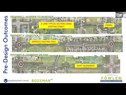
During the pre-design phase, the project team studied existing site conditions, conducted traffic and environmental analyses, and gathered community input on key design elements. This feedback has directly shaped the project’s evolution into its current design.
Thank you for staying engaged. We're glad you're here and look forward to continuing the conversation!
 Aerial view of the Fowler Avenue Corridor highlighting key focus areas identified in the 60% design plans, including intersections, pedestrian improvements, and connection points from Oak Street to Huffine Lane.
 What matters most for the future Fowler Ave?
What are the most important considerations for you as we design the Fowler Avenue Connection?
Whether you’re a neighbor, a Gallatin High student, or a commuter by bike, bus, foot, or car, we want to hear about your values, hopes, and concerns for this new transportation corridor.
Your responses here will be visible to other site visitors and help the project team prepare for further conversation with neighbors, commuters, and other community groups during the engagement process.
-
Share Is This Project Really Needed Right Now? on Facebook Share Is This Project Really Needed Right Now? on Twitter Share Is This Project Really Needed Right Now? on Linkedin Email Is This Project Really Needed Right Now? link
Is This Project Really Needed Right Now?

My name is Jack and I own a home on Sweetgrass Ave, the Fowler trail and open space is literally out my back gate.
In the Dec 12, 2021 Chronicle story: Lonsdale (city transportation engr.) said "he doesn’t know why the road wasn’t connected earlier but that it has been identified in transportation master plans over the years.”
Questionable statement – The current, 2017 Bozeman Transportation Master Plan doesn’t identify this segment of Fowler for any work, extensions, etc. It does identify some intersection improvements at Babcock St. and Durston Rd (pg. 82) as well as extending Fowler between Garfield... Continue reading
-
Share High Traffic Streets and Safe Backyards Don't Mix on Facebook Share High Traffic Streets and Safe Backyards Don't Mix on Twitter Share High Traffic Streets and Safe Backyards Don't Mix on Linkedin Email High Traffic Streets and Safe Backyards Don't Mix link
High Traffic Streets and Safe Backyards Don't Mix

As a Bozeman resident impacted by the upcoming Fowler Avenue Connection Project, I am grateful for the opportunity to share my thoughts regarding the project’s potential impacts. I hope that the city and design team at Sanderson Stewart will use the perspectives of the neighborhoods surrounding the project to balance the needs of a growing community with the safety and security of local residents.
My family and I moved to the Bozeman area from eastern Montana in 1990, and of course the Bozeman of today would have been unrecognizable to us then. We purchased a home in Bozeman in 2014
... Continue reading -
Share Buses and Shared Use Paths Move More People on Facebook Share Buses and Shared Use Paths Move More People on Twitter Share Buses and Shared Use Paths Move More People on Linkedin Email Buses and Shared Use Paths Move More People link
Buses and Shared Use Paths Move More People

Given the mechanics of how travel demand models (TDM) work it seems inevitable that three car lanes will not provide sufficient capacity to avoid future congestion. Paradoxically, this means we should have fewer lanes for cars.
According to Streetmix, for a same 80' right of way, a section with 13' shared use paths and two bus rapid transit lanes provides capacity for 83,500 people per hour, compared to the capacity of a road like North 19th Ave with five car lanes (and weird, intermittent shared use paths) that only provide capacity for 36,000 people per hour.
If the TDM... Continue reading
Who's Listening
-
NR
Email nross@bozeman.net -

Email tclark@bozeman.net -

Email jstaszcuk@sanbell.com -

Phone 406- 922-4330 Email dtolhurst@sanbell.com
Documents
-
 Fowler Pre-Design Report 8.1.2022 (8.51 MB) (pdf)
-
 Fowler Pre-Design Report Appendices
-
Appendix A - Traffic volume data.pdf (1.53 MB) (pdf)
-
Appendix B - Existing capacity calcs.pdf (1.21 MB) (pdf)
-
Appendix C - Volume projection memo.pdf (11.5 MB) (pdf)
-
Appendix E - Signal warrants.pdf (4.14 MB) (pdf)
-
Appendix D - Future capacity.pdf (5.34 MB) (pdf)
-
Appendix F - Opinions of propable cost.pdf (560 KB) (pdf)
-
Appendix G - Community engagement.pdf (15.6 MB) (pdf)
-
Appendix H - Environmental documentation.pdf (10.2 MB) (pdf)
-
Appendix I - Geotechnical report.pdf (7.4 MB) (pdf)
-
-
Community Engagement Summaries
-
Engagement Summary Transportation Board.pdf (212 KB) (pdf)
-
Engagement Summary - Community Services.pdf (148 KB) (pdf)
-
Engagement Summary - Neighborhood Focus Group #1 (150 KB) (pdf)
-
Engagement Summary - Schools Focus Group.pdf (162 KB) (pdf)
-
Engagement Summary - InterNeighborhood Council (INC) (263 KB) (pdf)
-
Engagement Summary - Natural Resources Focus Group.pdf (163 KB) (pdf)
-
Engagement Summary HOA Focus Group.pdf (162 KB) (pdf)
-
Engagement Summary Transportation Focus Group.pdf (164 KB) (pdf)
-
Fowler Engagement Summary Field Trip #1.pdf (173 KB) (pdf)
-
Fowler Engagement Summary Field Trip #3.pdf (158 KB) (pdf)
-
Fowler Engagement Summary Field Trip #2.pdf (170 KB) (pdf)
-
-
Fowler Community Engagement Meeting Slides.pdf (5.67 MB) (pdf)
-
Fowler Open House Presentation Boards.pdf (21.4 MB) (pdf)
-
Bozeman Commission Meeting Fowler 021522.pdf (3.17 MB) (pdf)
-
Fowler City Commission Staff Report (186 KB) (pdf)
-
30 PERCENT DESIGN PLANS.pdf (147 MB) (pdf)
-
MAY 2024 30 Percent Open House Boards.pdf (103 MB) (pdf)
-
60 PERCENT DESIGN PLANS.pdf (137 MB) (pdf)
-
JULY 2025 60 Percent Walking Tour Boards.pdf (29.6 MB) (pdf)
-
Feb 2026 Updated Design All Segments.pdf (7.03 MB) (pdf)


Videos
-
 Fowler Avenue Connection Community event presentation, hosted at the Public Safety Center by the City of Bozeman and Sanderson Stewart on May 8, 2024.
-
 City Staff and consultant Sanderson Stewart presented an overview of the Fowler Avenue Connection project to the Bozeman City Commission at their meeting on February 15, 2022.
A full version of the meeting, including the meeting agenda, can be found on the City's website under "City Commission Video"
City Staff and consultant Sanderson Stewart presented an overview of the Fowler Avenue Connection project to the Bozeman City Commission at their meeting on February 15, 2022.
A full version of the meeting, including the meeting agenda, can be found on the City's website under "City Commission Video"
-
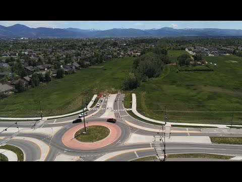
Drone video of the Fowler Avenue area from Huffine Lane to the Oak Street roundabout.
-
 On April 27th the Transportation Advisory board discussed the design alternatives posed to all of our focus group participants. You can check out what we heard from the board on lane configuration, intersection connections, multimodal infrastructure, and streetscaping in the video below! Discussion begins around 54:11.
-
See how each intersection option for Fowler would operate in this traffic simulation video.

Level of Engagement

Inform: Giving information to the community
Consult: Asking for the community's input on alternatives